Earliest people
Five thousand years under one Girvan field
Key dates
- Earlier fourth millennium BC
A large timber enclosure is built west of the plateau.
- Later Bronze Age and early Iron Age
Roundhouses occupy the higher ground.
- Late second century AD
The enamelled brooch is made in Gaul or the Rhineland.
- AD 422–547
Hazelnut shell from Kiln 1 falls within this radiocarbon range.
Show all 5 dates Show fewer dates
- 2020
Excavation reveals the field’s successive phases of use.
A small enamelled brooch made in the Roman world came to rest in a roundhouse boundary near Girvan. Blue enamel and coloured roundels still hint at the bright ornament it once was. Made in eastern Gaul or the Rhineland in the late second century AD, it was found in the fill of a timber palisade at the Curragh, five kilometres north-east of the town.[1]
The brooch was one find in a much longer story. Excavation before development at Girvan Distillery in 2020 uncovered a Neolithic timber enclosure, prehistoric houses and early medieval grain-drying kilns. The earliest traces are more than five thousand years old. Across widely separated periods, people returned to this ground to build, work and grow food.
A plateau at the mouth of a valley
The main excavation lay on and beside a low rocky plateau at a valley mouth, about 1.5 kilometres inland from the coast. Streams, woodland, workable stone and ground for crops made the surrounding landscape useful long before modern industry arrived.
Walls and roofs had gone, but postholes, gullies and hearths preserved the outlines of buildings. Packing stones still marked where timbers had stood. Later structures cut through earlier ones, leaving the traces of successive uses of the same ground.
In the earlier fourth millennium BC, people set substantial oak posts into an irregular rectilinear enclosure west of the plateau. The surviving alignments extended for tens of metres, too large and irregular to have carried one roof. Signs of burning and carefully placed pottery suggest that gatherings and ceremonial activity may have formed part of its use.[1]
Other finds bring us closer to everyday work. Fragments of carinated bowls, with their sharply angled profiles, came from several postholes. Soot and food residues showed that some had been used for cooking. Hazel shells were roasted in a fire-pit. Nearby groups of four posts may have supported raised platforms for storing grain.
Stone moving across the water
The tools and raw materials connect the Curragh to places beyond the valley. A flake of pitchstone came from Arran. The polished axe found in the 2020 excavation was made from greywacke, probably from Scotland’s Southern Uplands—an unusual material for such a tool. A different, smaller axe found during earlier work at the Curragh was made from Great Langdale tuff in Cumbria.[1]
These objects could pass through several hands in exchange. Their origins place the Curragh within networks around the Irish Sea, where water carried raw materials, finished tools and the people who knew how to use them.
A long gap separates the Neolithic remains from the next substantial sequence of dated structures, in the middle and later Bronze Age.
Houses on the higher ground
By the later Bronze Age and early Iron Age, people were building roundhouses on the plateau. One, known to the excavators as Structure 3, survived mainly as a ring of load-bearing postholes and an entrance passage. A nearby four-post building may have served it. Small traces of barley, emmer wheat and possible oats indicate cultivation, while vitrified material points to ironworking in the vicinity.[1]
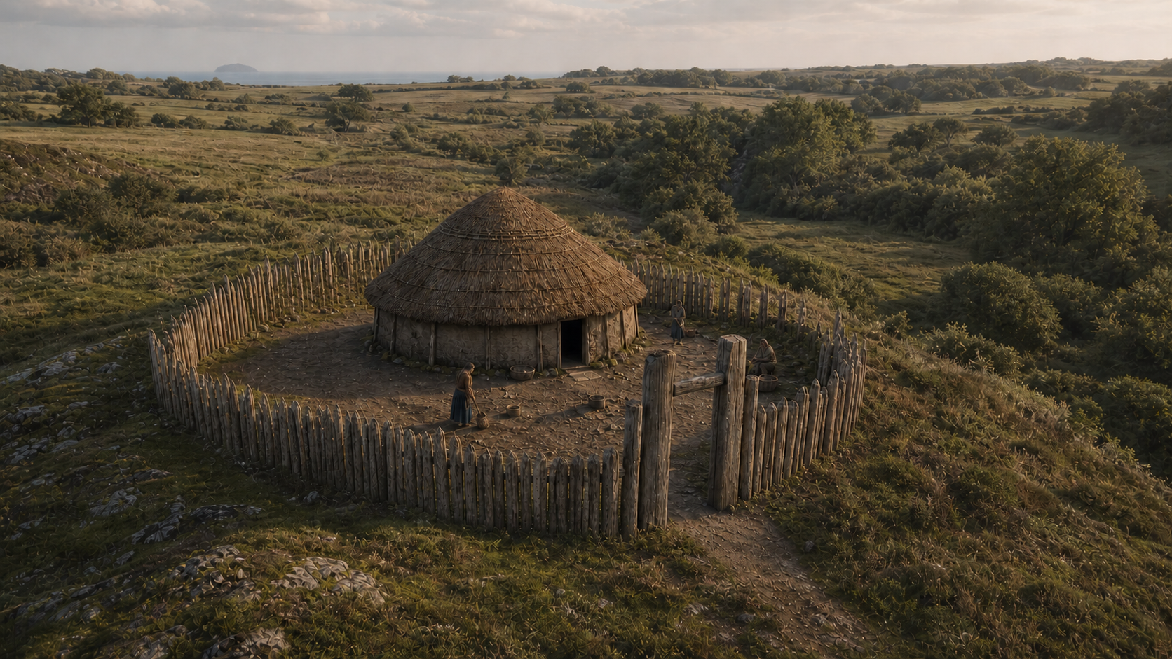
Centuries later, another house, Structure 1, occupied the higher ground. Its builders enclosed it with a timber palisade about 20 metres in diameter. On the north, the plateau dropped into a small valley, reducing the need for a substantial fence. Two large posts defined a gateway to the north-east.
The house changed during its lifetime. Posts were replaced or reinforced, and a fire-pit was capped with a large flat stone. Repairs and alterations survive in the ground alongside the original plan.
It was in this enclosure’s south-western boundary ditch that the brooch was found.
A brooch from the Roman world
The enamelled disc measures just under three centimetres across. Eight roundels alternate around its blue outer field. Inside them, a damaged band of millefiori—patterns made from slices of coloured glass—may once have formed a blue-and-white chequerboard. A raised central cup holds enamel now discoloured to pale green.[1]
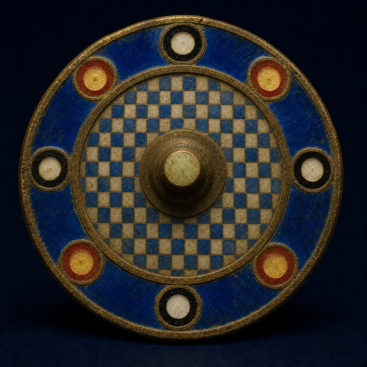
Although much of its margin is now missing, the catalogue identifies the brooch as having been deposited intact. A small loop on its edge was designed to hold a chain connecting it to a paired brooch. This was conspicuous personal jewellery.
Its position in the palisade ditch raises the possibility of deliberate deposition. Valued objects have been found at the entrances and boundaries of other Iron Age houses. The excavators suggest that the Curragh brooch may have been placed there when the enclosure was built, altered or abandoned, perhaps as an offering.[1]
Military connections are the most likely route by which this continental type reached northern Britain. The temporary Roman camps near Girvan, however, belong to an earlier period than the brooch. Its journey to the Curragh and the identity of the person who wore it remain unknown.
Barley after the roundhouses
The last major phase brought three large grain-drying kilns to the site. Hazelnut shell from the base of Kiln 1 returned a radiocarbon range of AD 422–547. The excavators considered an early medieval date likely, while noting modern plant material in the disturbed feature. Kilns 2 and 3 were undated; their similar form suggests they may belong to the same phase.[1]
Carbonised six-row barley survived in Kilns 2 and 3. Kiln 1 held only two indeterminate grains, with hazel charcoal in its flue. Drying made harvested cereal safer to store and easier to process. The scale of these dedicated kilns may indicate work beyond the needs of a single small household.
By then the Iron Age houses and their palisades had disappeared. Grain drying gave the ground another use.
What one field can hold
The Curragh’s higher ground, nearby water and woodland, and connections to the coast help explain its repeated use. The excavated phases span more than four thousand years, with long gaps between them.
Oak posts once marked out a Neolithic enclosure. Later households repaired their roundhouses on the plateau. A continental brooch entered a local boundary, and grain-drying kilns followed the houses. Beneath a field beside a modern distillery, the traces of that work survived.
References
[1] Jordan Barbour and Dave McNicol, Excavations at the Curragh, Girvan, Archaeology Reports Online 59 (2025). Read the excavation report. Site and enclosure: pp 7–11, 23–24, 44–45; houses: pp 13–20; axe and stone sources: pp 31–32; brooch catalogue by Fraser Hunter: pp 42–44; kilns and dating: pp 20–24. The separate 2016 Great Langdale axe is discussed on pp 31–32.
Pass the story on